High-resolution UAV mapping for weed and vegetation management of the Apsley Marshes and Moulting Lagoon Reserve
NRM South are undertaking a three-year project aimed at improving the management of land in the Apsley Marshes and Moulting Lagoon Game Reserve, which is one of 10 Ramsar recognised (wetlands of international importance) sites in Australia. The aim of their project is to be able to demonstrate differences in weed extent (particularly gorse) in relation to fenced (cattle/sheep free) areas, revegetation, and changes to drainage lines over the course of a three-year period. To achieve this, NBES were engaged to produce a photogrammetric dataset and quantify the extent of weeds and vegetation coverage within a 1500-hectare study area. Given the size of this study area, a ground-based survey was infeasible and was instead most suitable to be flown with an Unmanned Aerial Vehicle (UAV) combined with some ground truthing.
A registered drone pilot and ecologist tackled recently flooded and muddy field conditions to fly the 1500-hectare area in less than a week. UAV flights were conducted using a quadcopter fitted with a high-resolution camera. The airframe was deployed to capture imagery at 110 m altitude along pre-defined flight paths plotted over areas of interest. Almost 20,000 aerial images were captured of the reserve, which included areas within The Grange, Big Punch Bowl, Devils Corner and Apslawn.
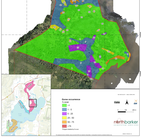
Captured images were then photogrammetrically processed to generate stitched, georeferenced imagery of the area, known as an orthomosaic. This orthomosaic was subsequently used to quantify weed and vegetation coverage throughout the area. Weed patches were digitised and classified based on coverage density, whilst vegetation was classified based on the TASVEG 4.0 mapping system.
Extensive patches of gorse were found to exist in areas adjacent to the wetland, with smaller patches of African boxthorn detected within isolated areas throughout cattle grazing zones.
The high-resolution imagery and digitised weed areas allow the implementation of targeted weed management strategies down to the centimetre level. It also provides a baseline dataset which can be used to measure change in weed and vegetation growth to assist NRM South’s desires to improve land management in the reserve.

